

GO 111 Hyderabad
Introduction
The GO 111 Hyderabad area covers roughly 538 sq km, around 1.32 lakh acres, and 84 villages associated with the catchment areas of Osman Sagar and Himayat Sagar. The original Government Order was issued on 8 March 1996 to protect the two reservoirs from pollution and uncontrolled development. It placed restrictions on specified activities within a 10-km radius from the full tank level of the reservoirs.
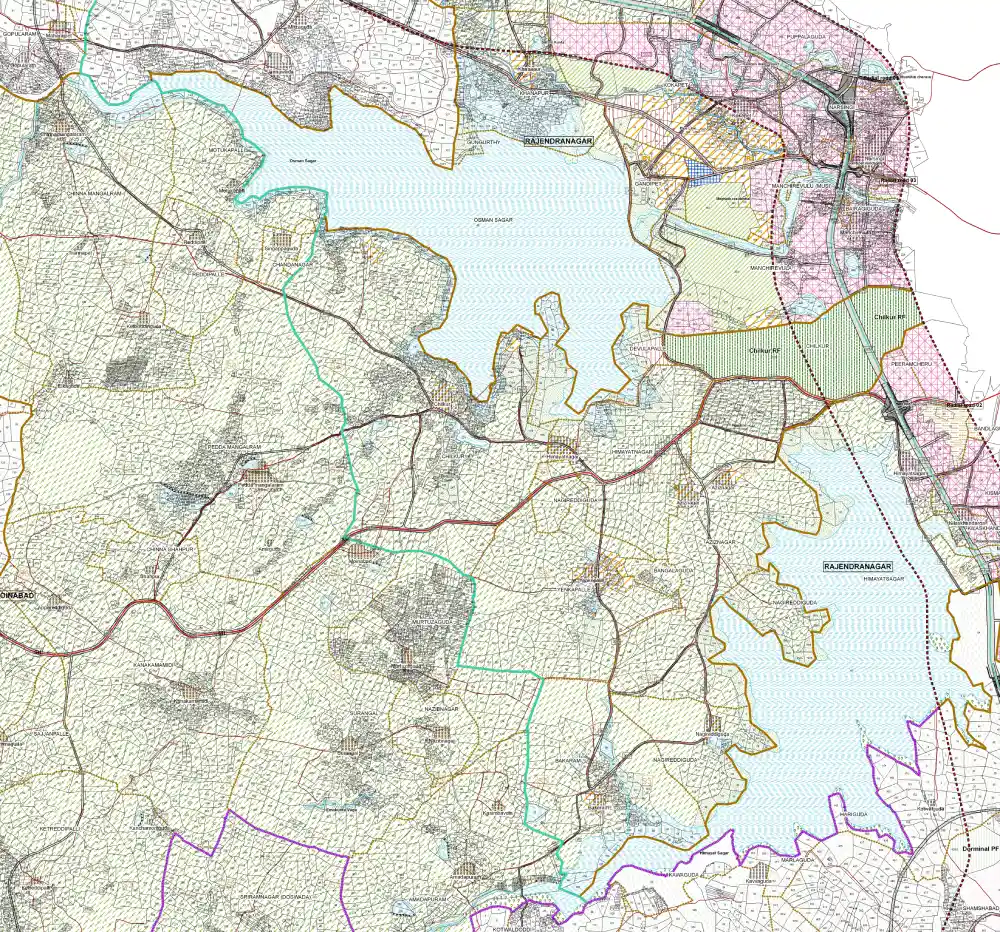
The position has changed several times since 2022. The Telangana government announced the removal of the restrictions, the decision faced legal challenges, and the government later continued examining what regulatory framework should apply to the region. In 2026, a high-powered committee recommended a controlled development model with environmental safeguards. The recommendations were still awaiting the government’s final decision in the latest reports available in 2026.
That uncertainty matters if you are looking at land in the former GO 111 area.
A plot being marketed as “GO 111 land” does not, by itself, tell you what you can build on it. The survey number, land use, catchment status, zoning and applicable permissions still need to be checked.
Key Highlights
- GO 111 covers 84 villages associated with the Osman Sagar and Himayat Sagar catchment areas.
- The area is commonly described as approximately 1.32 lakh acres or 538 sq km.
- The original restrictions date back to 1996 and were introduced to protect Hyderabad’s drinking-water reservoirs.
- The protected area was based on a 10-km radius from the full tank level of the two reservoirs.
- GO 111 was not simply a blanket prohibition on every land transaction. It regulated development and activities that could pollute or affect the reservoirs.
- The Telangana government announced the removal of the restrictions in 2022 and again announced the scrapping of GO 111 in 2023. Legal proceedings subsequently kept the matter under review.
- A high-powered committee examined how development could be permitted while protecting the reservoirs.
- The committee’s 2026 recommendations reportedly favour phased and environmentally controlled development rather than opening all 84 villages to unrestricted construction at once.
- The recommendations include scientific demarcation of catchment and non-catchment areas, stronger sewage treatment and protection of natural drainage channels.
- A plot described as “GO 111 land” should not automatically be treated as developable land. The exact survey number and current planning position matter more than the label.
What Is the GO 111 Hyderabad Area?
GO 111 refers to G.O.Ms.No.111, Municipal Administration and Urban Development Department, issued by the Government of Andhra Pradesh on 8 March 1996. The order amended earlier restrictions introduced in 1994.
The purpose was straightforward: protect the catchment areas of Himayatsagar and Osmansagar lakes, which were important sources of drinking water for Hyderabad and Secunderabad.
The order followed recommendations from the Hyderabad Metropolitan Water Supply and Sewerage Board and other agencies. It restricted polluting industries, major hotels, residential colonies and other establishments that could affect the reservoirs.
The geography can be summarised simply:
Osman Sagar + Himayat Sagar → 10-km protection area → 84 villages → about 1.32 lakh acres → roughly 538 sq km
That is the basic geography behind the term GO 111 green zone Hyderabad.
Total Catchment Area under GO 111
The specific figure is approximately 538 sq km. Government documents describe the area covered by the order as nearly 1.32 lakh acres and identify 84 villages.
| Measurement | Approximate figure |
|---|---|
| Area | 538 sq km |
| Area in acres | Nearly 1.32 lakh acres |
| Villages | 84 |
| Protection radius | Up to 10 km from FTL |
| Main reservoirs | Osman Sagar and Himayat Sagar |
| Original order | G.O.Ms.No.111, dated 8 March 1996 |
Why Does the GO 111 Area Exist Around Two Lakes?
The story starts with the two reservoirs.
Osman Sagar, also known as Gandipet, and Himayat Sagar were developed as major water reservoirs for Hyderabad. Rainwater from their surrounding catchments ultimately flows towards the reservoirs.
That made the way land was used around them important.
Construction, industrial activity, untreated sewage and other sources of pollution could affect the water entering the lakes. The government therefore introduced restrictions aimed at keeping the catchment areas from becoming heavily polluted or intensely developed.
This is why GO 111 catchment area is a more useful term than simply calling the region a construction-restricted zone.
At its core, GO 111 was about protecting water.
What Does the 10-Km Catchment Area Mean?
The original order refers to restrictions within 10 kilometres of the full tank level of Himayatsagar and Osmansagar.
That does not mean every parcel inside a 10-km circle has exactly the same planning characteristics.
Water does not move according to a perfect circle. Terrain, drainage channels and the direction of runoff all matter.
This distinction has become particularly relevant as authorities consider how the former GO 111 area should be regulated. The 2026 committee recommendations reportedly call for scientific demarcation of catchment and non-catchment areas rather than treating the entire region identically.
For a property buyer, the practical point is simple: distance from the lake alone is not enough to establish the planning status of a plot.
The survey number, official records, land use, drainage and applicable permissions need to be checked.
Which Villages Were Covered by GO 111?
The original GO 111 included an annexure identifying the villages falling within the protected area. The wider 84-village geography covers parts of mandals including Moinabad, Shamshabad, Rajendranagar, Chevella and Shabad.
| Mandal | Role in the GO 111 geography |
|---|---|
| Moinabad | Western portion of the protected region |
| Shamshabad | Southern and airport-side portion |
| Rajendranagar | Areas adjoining the western and south-western urban edge |
| Chevella | Western portion of the region |
| Shabad | Part of the wider southern-western area |
Complete Village List Under GO 111
S No. Village Name Mandal Name
1 Aziznagar Moinabad
2 Yenkatpally Moinabad
3 Mumtazguda Moinabad
4 Sajjanpalli Moinabad
5 Surgangal Moinabad
6 Naebnagar Moinabad
7 Bangallaguda Moinabad
8 Nagireddiguda Moinabad
9 Bakaramjagir Moinabad
10 Andapur Moinabad
11 Dargatdrula Moinabad
12 Venkatpuram Moinabad
13 Malkaram Shamshabad
14 Kolbawatidoddi Shamshabad
15 Sultanpalli Shamshabad
16 Yacharam Shamshabad
17 Rayangudda Shamshabad
18 Chowdariguda Shamshabad
19 Markhudda Shamshabad
20 Amapelli Shamshabad
21 Harrigudda Shamshabad
22 Kotwalguda Shamshabad
23 Shamshabad Shamshabad
24 Kishanguda Shamshabad
25 Ottapalli Shamshabad
26 Tondapalli Shamshabad
27 Devatabowli Shamshabad
28 Talkatta Shamshabad
29 Etbarpalli Shamshabad
30 Makanpally Shamshabad
31 Kattireddypally Shamshabad
32 Yenkamadi Shamshabad
33 Ramangipur Shamshabad
34 Kevatriguda Shamshabad
35 Mangipur Shamshabad
36 Jukal Shamshabad
37 Gandigudda Shamshabad
38 Peddashapur Shamshabad
39 Madanpally Shamshabad
40 Palmakula Shamshabad
41 Gangiraiguda Shamshabad
42 Cherlaguda Shamshabad
43 Hameedullanagar Shamshabad
44 Osettiguda Shamshabad
45 Gowlapallykand Shamshabad
46 Rashidguda Shamshabad
47 Syedguda Shamshabad
48 Gollapallekalan Shamshabad
49 Bahadurguda Shamshabad
50 Golkondakhur Shamshabad
51 Shakerpur Shamshabad
52 Sangiguda Shamshabad
53 Golkondakalan Shamshabad
54 Sollipet Shabad
55 Maddur Shabad
56 Gudur Kothur
57 Himayat Nagar Moinabad
58 Chikkoor Moinabad
59 Chanda Nagar Moinabad
60 Medipally Moinabad
61 Chinna Mangalaram Moinabad
62 Mothukupally Moinabad
63 Reddypally Moinabad
64 Pedda Mangalaram Moinabad
65 Khanpur Rajendranagar
66 Gunugurthy Rajendranagar
67 Vatti Nagulapally Rajendranagar
68 Janwada Shankerpally
69 Dhatampally Shamshabad
70 Maharajpet Shamshabad
71 Gopularam Shamshabad
72 Poddutur Shamshabad
73 Chinna Shapur Shamshabad
74 Tol Matta Shamshabad
75 Yenkapally Chevella
76 Yerlapally Chevella
77 Kanmeta Chevella
78 Gollapally Chevella
79 Raviapally Chevella
80 Mudimyal Chevella
81 Mumera Rajendranagar
82 Malakpur Rajendranagar
83 Tankutur Shankarpally
84 Bulkapur Shankarpally
A locality name is not enough when the question concerns an individual property. Buyers should check the actual survey number and current planning records.
What Did GO 111 Restrict?
GO 111 was primarily a water-catchment protection order.
The restrictions covered activities that could pollute the reservoirs. The government order referred to polluting industries, major hotels, residential colonies and other establishments generating pollution within the protected area. It also imposed restrictions on industries and included provisions relating to development intensity and land use.
The original framework also sought to keep a large part of the catchment under agricultural uses and restricted development intensity.
There were additional protections for the raw-water conduit from Osman Sagar towards Asifnagar, including buffer requirements along the conduit.
These restrictions help explain why large parts of the region remained less urbanised than western Hyderabad locations that developed rapidly during the same period.
GO 111 Was Not Simply a “No Construction” Rule
This is one of the areas where online discussions often oversimplify the original order.
GO 111 did not mean that every piece of land within 10 km was automatically identical or that every form of land use was prohibited. It restricted specified activities, development and pollution-generating uses and worked alongside other planning and environmental rules.
That is why statements such as these are too broad:
“All land inside 10 km was illegal.”
or
“Every plot outside the lake itself can now be developed.”
Neither statement gives a buyer enough information.
The more useful question is:
What is the current legal and planning status of this exact survey number?
Why Was GO 111 Changed?
Hyderabad’s water-supply system changed significantly after GO 111 was introduced.
In G.O.Ms.No.69 dated 12 April 2022, the Telangana government noted that the city’s installed drinking-water capacity had increased substantially. It said the dependable contribution from Osman Sagar and Himayat Sagar had fallen to less than 1.25% of the city’s drinking-water supply.
Based on that change, the government decided to remove the restrictions imposed under GO 111, while making it clear that the water quality of the two reservoirs should not be affected.
The 2022 order also proposed measures such as:
- Decentralised sewage treatment plants
- Diversion channels for treated water
- Groundwater-quality protection
- Reduction of pollution from agricultural runoff
- Other measures intended to protect reservoir water quality
A committee was constituted to frame detailed guidelines and regulations.
That decision marked a major shift in the GO 111 story, but it did not settle the issue permanently.
What Happened to GO 111 in 2023?
In May 2023, the Telangana Cabinet announced that GO 111 would be scrapped and that the land-use rules applicable in GHMC areas would be extended to the 84 villages.
The announcement generated considerable interest among landowners, developers and investors in the region.
The legal position became more complicated after that.
The government’s decision was challenged, and in September 2023 the Telangana government told the High Court that it would adhere to GO 111 until the expert committee submitted its report. The court also directed the government to continue following the restrictions while the matter was under consideration.
That is why the 2023 Cabinet announcement should not be read as meaning that every former GO 111 parcel immediately became freely developable.
GO 111 Status in 2026: What Has Changed?
The 2026 position is more complicated than saying either “GO 111 is active” or “GO 111 has completely gone.”
A high-powered committee examined the future of the region and submitted recommendations to the state government.
Reports in August 2026 said the committee had recommended replacing the old blanket restrictions with a more controlled development model. The proposals included phased development, stronger environmental safeguards and scientific identification of catchment and non-catchment areas.
The committee’s reported recommendations include:
- Phased development
- Scientific catchment and non-catchment demarcation
- Protection of natural drainage channels
- Strong sewage-treatment infrastructure
- Zero-liquid-discharge systems for specified developments
- Greater open-space and greenery requirements
- Lower-density development
- Continued restrictions on polluting industries
Reports also indicated that the government was considering starting with a limited number of villages within the ORR rather than opening all 84 villages at once. One report referred to around eight villages in the initial phase.
The important point is that these are committee recommendations, not a blanket development permission for all 84 villages.
Is the 40% Construction and 60% Green Space Rule Final?
No. This needs to be treated as a proposal, not as an existing entitlement.
The committee’s reported recommendations include increasing permissible development in certain areas from around 10% to 40%, while retaining the remaining 60% for greenery, roads and open spaces.
The proposed framework also calls for lower-density development and stronger environmental controls. Reports have mentioned green buildings, villa communities and resorts, while discouraging high-rise apartments and large concrete complexes in the proposed model.
But a buyer should not treat “40% development” as though it were already a final right attached to every plot.
The government still needs to decide the framework and issue the relevant rules, notifications and planning provisions.
For anyone buying land today, the safer approach is to base the purchase on current permissions, not on a future development percentage mentioned in media reports.
Why Is the 2026 Update Important for Hyderabad Real Estate?
The scale alone makes GO 111 important.
The region covers roughly 1.32 lakh acres and 84 villages. Any major change in its planning framework could influence the long-term development pattern on the western and southern sides of Hyderabad.
That does not necessarily mean the area will turn into another Kokapet or Financial District.
The recommendations reported in 2026 point towards a different type of development, with greater emphasis on:
- Green development
- Lower-density housing
- Villa communities
- Open spaces
- Environmental safeguards
- Drainage protection
- Sewage treatment
- Water conservation
The idea is to allow some urban growth without treating the entire region as a conventional high-density development zone.
What Does GO 111 Mean for Landowners?
For landowners, the biggest issue is still uncertainty.
A parcel that was difficult to develop under the old restrictions could become more valuable if the new framework allows additional uses. But that benefit will not be the same everywhere.
A property with:
- Good road access
- Clear title
- Suitable land use
- Favourable zoning
- No major drainage constraints
- Established development nearby
could have a very different outlook from an isolated agricultural parcel with poor access.
That makes a blanket “GO 111 premium” difficult to justify.
The location within the 84-village area is only one part of the valuation.
What Does GO 111 Mean for Plot Buyers?
For someone buying a plot, the first question should not be:
“How much will this land appreciate after GO 111?”
Start with:
“What can I legally do with this land today?”
Before paying an advance, check:
- Exact survey number
- Seller’s title
- Encumbrance history
- Land-use classification
- Layout approval
- Catchment or non-catchment status
- Current zoning
- Legality of the approach road
- Natural drainage
- Lake, nala and buffer restrictions
- Applicable environmental permissions
- Current HMDA and local planning requirements
- RERA registration, where applicable, for a plotted development
A broker saying that a property is “outside GO 111” is not a substitute for checking official records.
What Does GO 111 Mean for Investors?
The investment case has two sides.
The opportunity comes from the size of the land bank and the region’s connection to Hyderabad’s expanding urban footprint.
The risk comes from the fact that the development framework is still being decided.
It helps to separate the main stages:
| Factor | What it means |
|---|---|
| Historical GO 111 restriction | Limited development in the protected region and aimed to protect the reservoirs |
| 2022 government decision | Proposed removal of the restrictions and a new regulatory framework |
| 2023 Cabinet announcement | Announced scrapping of GO 111, followed by legal challenges and continued review |
| 2026 committee recommendations | Proposed phased, location-based and environmentally controlled development |
These stages should not be treated as though they are the same thing.
For an investor, the distinction is important because a policy proposal is not the same as a development permission.
GO 111 and Hyderabad’s Future Urban Expansion
The GO 111 region sits close to several western and southern growth corridors.
Locations around Moinabad, Chevella, Shankarpalli, Rajendranagar and Shamshabad have increasingly become part of Hyderabad’s wider property conversation. The ORR has also improved access to several peripheral areas.
But better connectivity does not automatically make every parcel developable.
The future planning framework will have a major role in determining which locations can support new development and at what intensity.
The 2026 recommendations’ focus on catchment and non-catchment demarcation makes this particularly relevant. Two properties in the same village could eventually have different planning conditions depending on their exact location and drainage characteristics.
GO 111 Area vs GO 111 Catchment Area
These two terms are often used interchangeably, but they should not always be treated as identical.
The GO 111 area refers to the broader area and villages covered by the government order.
The catchment area refers to land from which water drains towards the reservoirs.
The distinction matters because future planning is increasingly being discussed around the actual environmental characteristics of individual locations rather than treating the entire region as one uniform block.
The 2026 committee recommendations reportedly call for scientific identification of catchment and non-catchment areas.
For property buyers, a village name alone is therefore not enough.
The 84 Villages Are Not One Real Estate Market
Calling the entire region “GO 111 land” can make the market sound more uniform than it really is.
The 84 villages cover different directions around the twin reservoirs. Some locations have better access to the ORR, Shamshabad, Rajendranagar, Moinabad, Chevella, Shankarpalli or existing residential markets. Others remain more rural and depend heavily on future infrastructure.
The difference can be significant.
An investor should compare properties at the micro-market and survey-number level, not simply by asking whether a plot falls within the GO 111 area.
What Should Buyers Watch Next?
The next major step is the government’s decision on the committee recommendations.
The 2026 proposals point towards a regulatory framework based on controlled development, environmental safeguards and location-specific planning rather than unrestricted construction. The committee’s recommendations were expected to be placed before the State Cabinet.
The important items to watch are:
- Final Cabinet decision
- New government order or notification
- Final zoning rules
- Catchment and non-catchment demarcation
- Villages included in any first phase
- Development permissions
- Environmental conditions
- Sewerage and drainage requirements
- Building-density rules
- Green-space requirements
- Treatment of existing land uses
Until these details are formally notified, media reports about future development should be treated as policy developments, not guaranteed development rights.
Should You Buy GO 111 Land in Hyderabad?
There is no blanket yes or no answer.
For someone with a long holding period, legally clear land in a well-connected location may be worth researching.
For a buyer who wants to construct immediately, the bar should be much higher.
The difference comes down to timing.
A long-term investor can study how the planning framework may change. A buyer who wants to build now needs to know what permissions are available today.
A sensible order for due diligence is:
Title → Survey Number → Land Use → Catchment Status → Layout → Road Access → Current Permissions → Proposed Changes
Not:
Future GO 111 development → Expected appreciation → Purchase
That distinction can save a buyer from paying today’s price for tomorrow’s development rights.
Frequently Asked Questions
What is GO 111 Hyderabad?
GO 111 is a government order issued on 8 March 1996 to protect the catchment areas of Osman Sagar and Himayat Sagar. It imposed restrictions on specified development and pollution-generating activities within the protected area around the two reservoirs.
How large is the GO 111 area?
The area is commonly reported as approximately 538 sq km, or around 1.32 lakh acres, covering 84 villages associated with the twin-reservoir catchments.
Why is GO 111 called a 500 sq km green zone?
The more precise figure is about 538 sq km. “500 sq km” is a rounded description of the same broad region.
How many villages are covered under GO 111?
The commonly cited figure is 84 villages. They are spread across parts of mandals including Moinabad, Shamshabad, Rajendranagar, Chevella and Shabad.
What is the GO 111 catchment area?
It refers to the protected area associated with the catchments of Osman Sagar and Himayat Sagar. The original order applied restrictions within 10 km of the full tank level of the reservoirs.
Was GO 111 cancelled in 2023?
The Telangana Cabinet announced the scrapping of GO 111 in May 2023. The decision was subsequently challenged, and the government told the High Court that it would continue adhering to GO 111 while the expert committee examined the issue.
Can I construct on GO 111 land now?
Do not assume that every parcel in the former GO 111 area has unrestricted development rights. The applicable land use, zoning, catchment status, layout approval and government permissions need to be checked for the specific property.
What is the 40% construction and 60% green-space proposal?
Reports in 2026 described a committee recommendation under which development could potentially rise to around 40%, with the remaining 60% allocated to greenery, roads and open spaces in the proposed framework. This is a recommendation under consideration, not a blanket final rule for all 84 villages.
Is GO 111 land a good investment?
It can be worth researching, particularly for investors with a long holding period. The investment case depends on the individual property, including title, access, land use, zoning, catchment status and future development permissions.
Future policy changes should not be treated as guaranteed appreciation.
What are Osman Sagar and Himayat Sagar?
They are two reservoirs on the western and south-western side of Hyderabad. Protecting their catchment areas was the central reason for introducing GO 111 in 1996.
Final Takeaway
The GO 111 Hyderabad region is much larger than a typical residential micro-market. It covers approximately 538 sq km, 1.32 lakh acres and 84 villages linked to the catchment areas of Osman Sagar and Himayat Sagar.
That scale is one reason the issue continues to matter to Hyderabad’s property market.
The original order came in 1996 to protect the city’s reservoirs. Since then, the region has gone through several stages: the 2022 attempt to remove the restrictions, the 2023 Cabinet announcement, legal challenges and continued government review. In 2026, the discussion has shifted towards a more controlled development framework with environmental safeguards.
The direction now appears to be regulated growth rather than unrestricted construction.
For landowners and investors, the more important question is not simply whether GO 111 has been “removed.”
It is what regulatory framework replaces it, where it applies and what permissions it ultimately allows.
Until those rules are formally notified, buyers should verify the exact survey number, title, land use, catchment status, zoning, road access and development permissions before committing money.
The 84 villages may become an important part of Hyderabad’s long-term expansion story. But the value of an individual land parcel will depend on planning, infrastructure, environmental safeguards and legal clarity—not the GO 111 label alone.
Research cutoff: October 2026. Government policy, zoning and development permissions can change. Property buyers should obtain independent legal and planning advice before purchasing land in the former GO 111 area.
Pingback:Hyderabad Real Estate Market - YS Realty
Can we plan to construct A grade warehouse in Rashidguda village of shamshabad mandal in 5 acres land available with us
Yes you can with required permissions. There are many warehouses in the vicinity already.
Mera plot Ramanujapur me hai kya me sale Kar sakta hun
Yes you can. But we dont serve in that area
Ramanthapur is not in 111 as far as I know. Only Jatwada of Shankarpally is in 111.
I have a plot of land 36×75 sq yards
300 sq yards in Chowderiguda grampanchayat, Can I construct my house here, if yes whom to contact for required permission.
Yes you can if it falls under the village. Permission process is same as any other place, except you have height restriction.
Is plot number 390 vnr park lane shamshabad village vendor m/s snehitha builders private limited under go111
I have 1800 Sq.yards land in peddamangalaram Moinabad within village population area ,
Can I construct 4 houses comprising of 300 sq yards each in my land ? Do I need any special permission / approval for this?
Pls reply thankyou,
I need to have more specifics about the location, is it a village plot or and agriculture land. Since the land is in GO 111, you may have to use only 10% for construction.
If have a plot of 110 square yards in shamshabad , near railway gate, will i get a home loan, and the plot is under survey no.19?
Hi sir
I have 5gunta in shamshabad new city venture in brindavan colony.Can i build farmhouse in it.
How much construction is allowed? Floors and sft
You can only use 10% of the land and construct G+1
I have half acre agricultural land in appareddygudam village in Moinabad. I checked list of 84 villages listed in GO 111 and appareddygudam village is not part of that list. Can I create plots layout? if yes, whom should I get get permission from?
Do you have service regarding plotting and help me in getting layout permission?
If I cannot create layout, can I create G+1 house and from where I should take building permission?
It comes under GO 111
Can I create a G+1 house in 10% of land of total land? Should I get panchayat secretary permission for it?
I have a plot of 200sq.yrds in shamshabad, which is in DTCP layout. Can I construct G+1 for residential purpose? or do we have any restrictions here
Yes you can.
We are living in green zone area but we dont about at that time but now over area living more than 300 houses in green zone area any problms will come us like they will demolish our houses..?
No, until you follow the rules of 60% (Village) and 90% (agrilands) open area, the authorities wont bother you.
1. What is the building height restriction in GO111 area ?
1.1: Is this restriction same throughout the area under GO111 or does it vary depending on the plot/villa distance from lake or whether the plot is in local village or a farm land ?
2. Are borewells allowed in GO111 ?
3. Are there any development zones in GO111 along the new by-pass road from AzizNagar to Chevella ?
3.1 : Are there any relaxation in rules ?
1. What is the building height restriction in GO111 area ?
No explicit height limit. Only FSI 0.5 and 60% open space required.
1.1: Is this restriction same throughout the area under GO111 or does it vary depending on the plot/villa distance from lake or whether the plot is in local village or a farm land ?
Rules are uniform across the entire 10 km catchment area.
2. Are borewells allowed in GO111 ?
No such restrictions
3. Are there any development zones in GO111 along the new by-pass road from AzizNagar to Chevella ?
No zones or special relaxations mentioned in the GO.
3.1 : Are there any relaxation in rules ?
Controls apply uniformly to all listed villages.